Posts: 419
Threads: 1
Joined: Jun 2015
Reputation:
32
(07-30-2016, 06:44 AM)Canard Wrote: The new tracks are now fully laid (and connected) through Erb/Caroline.
They were flooding with ballast this morning. I hadn't been through in some time and was excitedly hoping they were ready to switch the heavy rail over tonight (there's a derail sign on the new track)... but the track just peters out at King, connected to nothing, so boo-urns.
I wonder how they're going to connect the new with the old at King. The single-welded rail through Waterloo will be smooth sailing for the freight trains used to 12-foot rail segments.
Posts: 6,905
Threads: 32
Joined: Oct 2014
Reputation:
224
Probably sort of how they've been temporarily been doing it along the Waterloo Spur so far (well, mostly last fall) - they just drill holes in the side of the new rail, and use fish plates to bolt the rail segments together.
Posts: 1,094
Threads: 3
Joined: Aug 2015
Reputation:
57
Curbs are being poured on Duke from Water to Young right now
Posts: 56
Threads: 0
Joined: Sep 2015
Reputation:
0
08-02-2016, 04:45 PM
(This post was last modified: 08-02-2016, 04:51 PM by ert86.)
Lost of work at Conestoga Mall today. Paving Northfield, concrete pouring at the station and i think some of those pre-rolled rail sections were put down recently.
Also, I find it odd that they need 2 signals on Columbia/University, you'd think someone would have invented a 2 in 1 signal that blocks both the road and sidewalk. With the craziness of Pokemon Go, having signals that block sidewalks was actually a smart idea, given how absent minded they are.
Posts: 6,905
Threads: 32
Joined: Oct 2014
Reputation:
224
The pedestrian signal arms are standard fare for railways.
Posts: 6,905
Threads: 32
Joined: Oct 2014
Reputation:
224
<blockquote class="twitter-tweet" data-lang="en"><p lang="en" dir="ltr">Beautiful evening tonight along the line. <a href="https://twitter.com/hashtag/wrLRT?src=hash">#wrLRT</a> <a href="https://t.co/zyNxhaosHU">pic.twitter.com/zyNxhaosHU</a></p>— iain (@Canardiain) <a href="https://twitter.com/Canardiain/status/760642237319577600">August 3, 2016</a></blockquote>
Disclaimer: Was at the hospital anyway - wasn't using the parking lot just for taking photos!
Posts: 2,015
Threads: 11
Joined: Oct 2014
Reputation:
77
1) re: the tram sign; if it is a prototype, why bother to physically make it and mount it before tweeting an image out to get feedback?
2) re: the pedestrian crossings along the hydro corridor; the project agreement says that all the "crossings" are to be closed by the project co. I don't think this approach will work and kind of creates a bit of a "food desert" for some. Humans are lazy (or perhaps efficient) and will take the path of least resistance, especially when it comes to basic needs, shelter, food, employment, the former in abundance along Traynor (and the surrounding neighbourhood) and the latter two are in abundance along Fairway. People will cross the tracks so why not take the harm reduction approach and make the crossings as simple and safe as possible so that the majority of people are crossing at predictable locations and predictable times. I was running along that stretch of the hydro corridor very early Sunday morning and saw at people hopping fences and crossing the tracks at two different places already (I also noted one former opening/gap in the otherwise unbroken fence, but I think will end up being a locked gate for maintenance purposes and not a formal crossing).
Everyone move to the back of the bus and we all get home faster.
Posts: 6,905
Threads: 32
Joined: Oct 2014
Reputation:
224
08-02-2016, 09:59 PM
(This post was last modified: 08-02-2016, 10:00 PM by Canard.)
(08-02-2016, 09:56 PM)Pheidippides Wrote: 1) re: the tram sign; if it is a prototype, why bother to physically make it and mount it before tweeting an image out to get feedback?
The reason I was given was that they wanted to see what it looked like in before making hundreds, and get feedback (and boy, feedback did they get). Based on that feedback, an improved version will be coming (which I'm very happy with, since it's a new Ontario LRT standard! Standards are fun.)
Posts: 1,094
Threads: 3
Joined: Aug 2015
Reputation:
57
08-03-2016, 06:35 PM
(This post was last modified: 08-03-2016, 06:45 PM by GtwoK.)
Duke, from Water to Young
![[Image: wMVpG22.jpg]](http://i.imgur.com/wMVpG22.jpg)
![[Image: xphtdRC.jpg]](http://i.imgur.com/xphtdRC.jpg)
![[Image: CzIdfp8.jpg]](http://i.imgur.com/CzIdfp8.jpg)
Hm. Duke / Young is currently closed for 10 days (well, 5 more now). I assumed it'd be for track placement as I'm not sure why they'd need such a short closure or why they'd want to close it AGAIN after this. But just walked by and there's not even a hole in the ground. Just fences blocking entry for no apparent reason. Think they'll pull another Queen and spend the last 3 days installing track?
Posts: 6,905
Threads: 32
Joined: Oct 2014
Reputation:
224
Posts: 6,905
Threads: 32
Joined: Oct 2014
Reputation:
224
Posts: 2,015
Threads: 11
Joined: Oct 2014
Reputation:
77
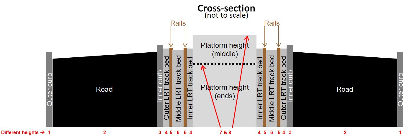
Is the GRH platform designed to be accessed from the north? I ask because I was looking at it the other day and there are no curb cuts that align with that end of the platform’s ramp and there are at least eight (8) different levels of concrete and track to traverse (see diagrams below) without a proper ramp and level crossing. Would that mean you’d have to walk up the middle from Mt. Hope to access the north end of the platform or is it only to be officially accessed from the south (at Pine St)? Has this type of design, with so many different levels on the cross-section, been used in other winter climates? The more I see this design the greater my concerns for snow and ice clearing grows.


Also, a similar question about the UW platform. How are they expecting users to access the platform from the south, say when you are coming from east campus/E5 to the platform or going from the platform to east campus/E5? The drawings ( http://rapidtransit.regionofwaterloo.ca/...df#page=10) seem to suggest that a path was supposed to be built on the east side (yellow line in diagram below), but that no longer seems to be the case since the retaining wall and fence are now complete. The path they expect users to take (green line in diagram below) which is a longer route. I expect that many users will simply take a risky shortcut (red line below).

Everyone move to the back of the bus and we all get home faster.
Posts: 6,905
Threads: 32
Joined: Oct 2014
Reputation:
224
08-04-2016, 06:51 AM
(This post was last modified: 08-04-2016, 08:33 AM by Canard.)
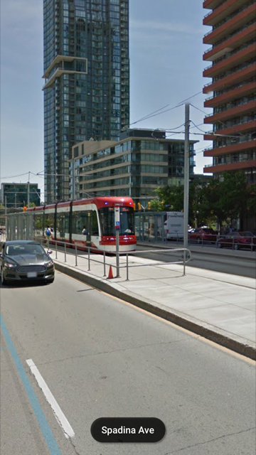
No one will be crossing 8 different heights by design (and they certainly won't be walking down the centre of the Rapidway). If they are, they're crossing at a spot that is not a designated crossing. I don't know what the design is, but the platforms seem to be all poured as "standard" with ramps at both ends. On King at the Hospital, the South end of the platform is how you'll get to it, from the pedestrian crossing at the road there.
At the North end of the platform, it'll probably (hopefully?) be like what's done in other places, where there is a railing or fence that discourages access from places that people shouldn't be crossing:

Posts: 4,393
Threads: 15
Joined: Aug 2014
Reputation:
121
Very pleased to spot the welding crew by Full Circle just now. Once that is welded and the track embedded, it will close the final gap on Charles within the downtown loop!
Posts: 6,905
Threads: 32
Joined: Oct 2014
Reputation:
224
08-04-2016, 01:00 PM
(This post was last modified: 08-04-2016, 01:01 PM by Canard.)
Yeah! Now just need to get the section by Cameron Heights finished. When I rode by last night, it looked like there has been no activity here for a week or two (Charles, Benton to Borden). Everyone on the crew has moved up to Northfield, it seems. As per last night's photo update, you can see that both embedded curve rails on Northfield still need welding before they can be mounted to the green steel ties. Maybe that will happen in the next few days.
|


![[Image: wMVpG22.jpg]](http://i.imgur.com/wMVpG22.jpg)
![[Image: xphtdRC.jpg]](http://i.imgur.com/xphtdRC.jpg)
![[Image: CzIdfp8.jpg]](http://i.imgur.com/CzIdfp8.jpg)