Posts: 6,905
Threads: 32
Joined: Oct 2014
Reputation:
224
08-15-2015, 08:38 AM
(This post was last modified: 08-15-2015, 09:30 AM by Canard.)
Hey everyone,
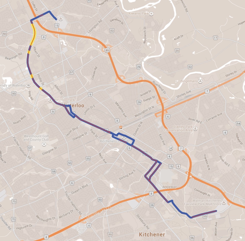
I have an idea for something, but I'm not really savvy with computer graphics programs. I think it would be great to have a "live document" that we could all contribute to, that would be a map of the route and we could mark it up showing construction progress. I think everyone checks out their own favourite sections of the route (like Markster goes along the Laurel Trail in uptown waterloo, KevinL posts about the work on Caroline, I drive up to the OMSF a lot...), so if we could all have access to some kind of map we could colour-code in like, where they are at with each section. Red line could be ground/dirt work, blue line could be services and utility work, green line could indicate the completed track, that kind of thing. Right now there would just be a green line from the OMSF South to behind McCormic Arena, and then very short green lines at Bearanger, Columbia, and University crossings, etc...
What do you think? Or is this a job for a multi-contributor Goggle Map?
Edit - Looks like Google Maps is the way to go! I've used the Functional Design Drawings to lay out the route as a layer; Blue is the route, red is ground prep, yellow is completed track.

Posts: 4,325
Threads: 1
Joined: May 2015
Reputation:
180
(08-15-2015, 07:30 AM)Canard Wrote: (08-14-2015, 10:11 PM)KevinL Wrote: Edit: Looking at the markings, each welded piece is 560 feet and there will be 30 of them. That's 5.12 km of track just in this load.
5.12 km of rail... 2.56 km of track 
1.28km of double track!
So there will be lots more rail still to come, probably at various locations along the line. I assume everybody here knows about the rail-welding operation that just finished near the former tourist train station in Waterloo? There are dozens of long strings laid parallel to the tracks there, clearly more than will be used in that immediate area. I suspect the rails for Caroline St. are included in that batch.
Posts: 6,905
Threads: 32
Joined: Oct 2014
Reputation:
224
08-15-2015, 09:31 AM
(This post was last modified: 08-15-2015, 10:24 AM by Canard.)
Yeah - scroll up to KevinL's post above; the Holland rail welding team are now on Charles, welding together the sections there.
Why this is super-exciting: it means this section of road will not reopen until the tracks are in the ground... Which means we'll likely see that happen within the next 3 months!
Posts: 4,391
Threads: 15
Joined: Aug 2014
Reputation:
121
(08-15-2015, 09:27 AM)ijmorlan Wrote: (08-15-2015, 07:30 AM)Canard Wrote: 5.12 km of rail... 2.56 km of track 
1.28km of double track!
All true! Thanks for the corrections, folks. 
Posts: 1,189
Threads: 0
Joined: Mar 2015
Reputation:
34
(08-14-2015, 11:29 PM)MacBerry Wrote: (08-14-2015, 08:16 PM)Pheidippides Wrote: Research and Technology station
August 15, 2015
Is that some sort of concrete form?
![[Image: 2cz6o8g.jpg]](http://i61.tinypic.com/2cz6o8g.jpg)
What does everyone think the LRT users will call the Research and Technology Station? Users will never stick with that politically motivated name and the too long when your drunk name?
"I'm only going as far as "RTS"?
I get on at the "RT" and off at "Caroline"!
Thoughts on this name mess and the others?
Possibly the same name as the current iXpress stop: R&T Park?
Or maybe "North Campus"? "Phillip"? "That stop nobody uses"? 
Posts: 6,905
Threads: 32
Joined: Oct 2014
Reputation:
224
Posts: 6,905
Threads: 32
Joined: Oct 2014
Reputation:
224
08-16-2015, 03:33 PM
(This post was last modified: 08-16-2015, 07:43 PM by Canard.)
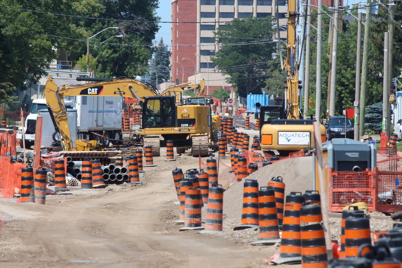
 A water line with quick-connect couplings is being installed on Courtland.
 Looking Southwest down Borden from Courtland Avenue.
 Looking Northbound on Charles.
Posts: 4,391
Threads: 15
Joined: Aug 2014
Reputation:
121
08-16-2015, 06:46 PM
(This post was last modified: 08-16-2015, 06:47 PM by KevinL.)
Middle photo in the second post is Borden alongside Schneiders, yes? That's looking really good.
Incidentally, I understand University Ave is now reopened!
Posts: 6,905
Threads: 32
Joined: Oct 2014
Reputation:
224
08-16-2015, 07:41 PM
(This post was last modified: 08-16-2015, 07:45 PM by Canard.)
Yeah that's right, it's Borden! There was a big foundation and cover on the "South" corner, for what looked to me like a big stoplight pole or train warning light pole. It unfortunately basically decimated that person's yard.  The North West side of Borden where the tracks go looks like it has for a week or two now, no signs of Overhead Conductor System (OCS/"Catpole") work that I could see.
The latest ion update suggested that work at the Seagram crossing would start tomorrow, so that makes sense with the timing of University being back open as they move all their equipment over there!
On the subject of the warning lights, I really am curious to see what the final design of all the intersections will be with respect to lights, mechanical barriers, etc. - I know it's marked on some of the Design Reference Documents, but there are a lot of areas that aren't, that I think will need to have something... Houston's system has gone totally overboard with this because they had so many crashes but their warning lights are really sharp - many of the stop lights (just regular 3-lamp traffic lights) have an additional red/orange rectangular"Halo" around the outside that illuminates when a train is approaching.
Yesterday, August 15, was the one-year anniversary of groundwork for the project. 
Posts: 2,163
Threads: 17
Joined: Sep 2014
Reputation:
76
(08-16-2015, 07:41 PM)Canard Wrote: The latest ion update suggested that work at the Seagram crossing would start tomorrow, so that makes sense with the timing of University being back open as they move all their equipment over there! Seagram actually started on Friday. It was closed that day. A lot of traffic that was expecting to use it to detour around the University closure was a bit surprised!
Quote:On the subject of the warning lights, I really am curious to see what the final design of all the intersections will be with respect to lights, mechanical barriers, etc.
Yeah, I'm wondering this too. Crossings like University and Columbia are totally appropriate for traditional rail gates, and I'm wondering if they'll go that way. I can't imagine them putting gates in for the street-running sections.
Posts: 1,094
Threads: 3
Joined: Aug 2015
Reputation:
57
I'm curious now; when they have all the "utility work" (ie water mains, sanitary, storm) to do on the roads that the track will be running along, what is it they're actually DOING? I had hypothesized that they would want no interruption to to Ion service at any point, and therefore no construction involving track removal. As such, they were probably replacing water mains et al to something permanent, that would't require ever being replaced.
Looking at the photos of Borden now, the road and curb seem to be relatively in the same place as before, and could still have the wet works running beneath the road with no interaction with the Ion track. So what are they doing for these many months per stretch of road regarding wet works?
Posts: 1,227
Threads: 6
Joined: Oct 2014
Reputation:
31
(08-16-2015, 09:11 PM)Markster Wrote: Quote:On the subject of the warning lights, I really am curious to see what the final design of all the intersections will be with respect to lights, mechanical barriers, etc.
Yeah, I'm wondering this too. Crossings like University and Columbia are totally appropriate for traditional rail gates, and I'm wondering if they'll go that way. I can't imagine them putting gates in for the street-running sections.
I think they will need mechanical barriers in all cross intersections. Particularly along King when left turns are allowed. Unless they do this, people will try to start a turn left into the red light at the same time as the train is coming.
Posts: 744
Threads: 2
Joined: Aug 2014
Reputation:
11
(08-16-2015, 09:51 PM)GtwoK Wrote: I'm curious now; when they have all the "utility work" (ie water mains, sanitary, storm) to do on the roads that the track will be running along, what is it they're actually DOING? I had hypothesized that they would want no interruption to to Ion service at any point, and therefore no construction involving track removal. As such, they were probably replacing water mains et al to something permanent, that would't require ever being replaced.
My understanding/guess is that it is a combination of moving the utilities so they are not under the tracks, and setting up the utilities in such a way that they can be serviced from the side (in particular, at intersections).
Posts: 141
Threads: 2
Joined: Sep 2014
Reputation:
2
(08-16-2015, 03:33 PM)Canard Wrote: A water line with quick-connect couplings is being installed on Courtland.
Looking Southwest down Borden from Courtland Avenue.
Looking Northbound on Charles.
In the Borden shot, thos white bags on the right side look like concrete bases? CAT pole bases?
Posts: 2,163
Threads: 17
Joined: Sep 2014
Reputation:
76
(08-16-2015, 10:31 PM)BuildingScout Wrote: I think they will need mechanical barriers in all cross intersections. Particularly along King when left turns are allowed. Unless they do this, people will try to start a turn left into the red light at the same time as the train is coming. Is that not the point of the red light? To stop people from turning?
Street running LRT in Seattle, Portland, and LA manage to survive without crossing bars at all conflict points.
|


![[Image: 2cz6o8g.jpg]](http://i61.tinypic.com/2cz6o8g.jpg)

 The North West side of Borden where the tracks go looks like it has for a week or two now, no signs of Overhead Conductor System (OCS/"Catpole") work that I could see.